Showing posts with label History. Show all posts

Sunday, April 29, 2012

Gate-Crashing Yokohama...When Is Wednesday Also A Mon-Day?


Chinatown is approached through a number of gates, or mon in Japanese (門), in traditionally flamboyant style... though they can be slightly odd, sitting in amongst the normal traffic signs. There are 10 gates all up in Chinatown, arranged according to the Chinese art of Feng Shui - bascially a throwback to the ancient beliefs relating to superstition to shape, structure and colour. The first four are the most important, relating to the Four Symbols in the Chinese Constellation. Whilst it was my intent to take snaps of them all, the reality was that the oppressive heat beat me. So here's just a few of the shots that I did manage to take before heat exhaustion threatened to get to me. I've also made use of Google StreetView to help with the rest... it's kinda cheating, but... I've also made use of the info on the official Chinatown website - though unfortunately this part is in Japanese only.

I've made up the map below so you can reference the gates by numbers (in no particularly meaningful order):
Map care of Google Maps.

1. The East (東) Gate or  Chouyou-mon (朝陽門). This gate relates to the Azure Dragon God, and brings prosperity. The Azure Dragon is said to relate to the East, and Spring - and is associated with the wood element. It was only opened in 2003, and is the largest of the gates.

1. Chouyou-mon

2. South (南) or Suzaku-mon (朱雀門). This gate is associated with the God Suzaku - the Vermillion Bird - and hence the colour red. It relates the generation of good fortune from disaster, and is also related to the fire element, the direction South, and the season Summer.

2. The Suzuka Gate (source: Google StreetView)


3. The North (北) Gate or Genbumon (玄武門). This gate relates to the Black Tortoise, and is associated with the God Xuanwu (in Chinese) or Genbu (in Japanese). The gate is linked both to the North and to the season of Winter.
3. Genbu-mon (source: Google StreetView)
4. The West (西) Gate or Enpei-mon (延平門). This gate is related to the White Tiger God of Chinese astrology, and is known by Baihu (in Chinese) or Byakko (in Japanese). Actually the White Tiger (the West Gate) and the Azure Dragon (the East Gate) were said to be brothers, and reincarnated as two ancient Chinese generals. It represents the direction of West, the colour white and the season Autumn. The gate relates to eternal peace, as the legend goes, the tiger's tale turns white at the age of 500, and only appears when peace exists across the world.
4.  The Enpei-mon (source: Google StreetView)
5. The Prayer for Good-Neighbourly Gate (平和を願う善隣門) or Zenrin-mon. This gate was originally constructed in 1955 when the area was known as Nanjing Town. It was later re-signed as Chinatown, and renovated in 1989. It is perhaps the symbol gate for all of Chinatown now.
5. Zenrin-mon

6. The Chikyumon or Earth Gate (地久門). This is the first of the pairs of gates that stand at the Western and Eastern ends of Kanteirou dōri , which are basically representing Heaven and Earth (or... should that be Earth and Heaven). There are two important areas that can be accessed from this road, but I'll talk about them in subsequent posts. The matching gate is gate 7.
6. Chikyumon
7.  The Tenchoumon or Heaven Gate (天長門). The second and Eastern of the two gates.


8. and 9. The Market Street Gate or Ichibadōrimon (市場通り門). This is the second of the pairs of gates, and can be found, not surprisingly, on Ichibadōri. It may not quite look like it today, but this street is normally a thriving centre of activity. I'll explain why that wasn't the case in the next post...
8. Ichibadōrimon (1)

9. Ichibadōrimon (2)

10. The Seiyō or Closest to the Western Sun Gate (西陽門). This gate is named so as it's supposedly closest to the Suns light on the Western side. Hmmm - looking at the map on Google, I'm not entirely sure about that. To be honest, it's also a very strange place to have a gate, snuggled as it is right next to an over-pass.
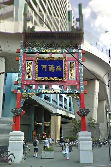
10. Seiyō Gate (source: Google StreetView)

Looking back at the Eastern Gate, there's a lot of detail in their construction - as is the wont for Chinese gates. There's a lot of work in these things, and I do wonder if it's a specific set of skilled artisans that go around the country (or the world) making Chinese gates. A little note of explanation. Each of the gates have two signs... the outer side (see the first image above) says Chinatown, the inner side gives the gates name. Below is the sign for the Chouyon-mon or  朝陽門 ... in Chinese characters, this is read, right to left...門陽朝..


Whilst the light was not the best for photographing (hmmm... this was clearly before I started playing around with HDR photography), I love the complete crazy psychedelic colours in the Chinese (Japanese) architecture... I can just imagine what it would have been like back in the day, being a paint salesman in ye olde Japan


Subtlety was not one of their strong points, I fear....


I'm not sure how long the gate took to complete, but it's certainly an amazing work or art, and a grand way to welcome anyone into Yokohama's Chinatown. Whilst. I'm not sure if gate-spotting as a hobby will catch on, but it is fun to explore the whole of Chinatown to see them all. Although I've still got 4 to find on one of our next trips.

Sunday, November 28, 2010

Old Hokkaido Government Building... Made in USA (almost)

13th May, 2008 - Following on from our walk around the Botanic Gardens, we took L-kun for a walk around the Old Hokkaido Government Building near the Grand Hotel (actually the Grand is where we had our pre-wedding party back in 2003). Last time we were walking here it was February 2003... and there was quite a different look and feel to the place this time around (something to do with being able to feel your extremities I suspect). At that time, it was snowmen rather than flowers that dominated the scenery. On this occasion, cherry blossoms, not snow, formed a blanket on the lakes surface.

It's often easy to get the view of Japan as an ancient and homogeneous country, and in many ways this is true. However, Hokkaidō is a relatively new addition to what is traditionally considered Japan. It was initially populated by the Ainu people, a culturally, linguistically and racially different people from mainstream Japanese.  As is often the case with aboriginal peoples, they had a somewhat difficult time coming to terms with maintaining their own way of life, whilst trying to cope with the external Japanese expansion from the south. In fact, it was not until the Muromachi Period (from the mid 1300's) that a form of permanent Japanese presence came to the island, though this was always a somewhat loose form of feudal Japanese control.

It was not until the Meiji Restoration that the Northern Island of Hokkaidō was fully opened up... both as a response to the pro-shogunate forces that had established a break-away province which was finally crushed in Hakodate in 1868 (during the Boshin War) - but also as a response to the growing threat of Russian expansion. As a result, the Japanese population of the island increased five-fold in the space of 10 years. The newly developed city, established officially in 1868 also became the capital of the island; the original government building can now be seen in the Historical Village in Sapporo. With the reformation of the political structure of the island, a new Government building was constructed based on a very American inspired design. Actually, whilst the look was very much American - the actual design was Japanese. 

The Hokkaidō Government Building (Hokkaidōchō kyūhonchōsha) was actually destroyed by fire in 1909... though apparently the tough old red-brick exterior suffered little damage. Now those red-bricks provide a somewhat jarring counterpoint to the modern Japanese buildings; in addition to the octagonal dome which was all the rage back in the States at the time.

These days the building is known not only for it's distinctive architecture, but also it's beautiful gardens. And tulips form a dramatic focal point come spring-time.

But the grounds contain a nice assortment of trees and water features, and you can have a good stroll through the extensive gardens. It's only about a 5-10 min walk from Sapporo Station, and is well worth the time. Admission to the grounds and building is free.

There were a couple of Americans who were central figures in the agricultural development of Hokkaido during the early days of the islands re-development - one was Horace Capron, and the other was William S. Clark who started the first agricultural college in Japan, and who is famously recorded as saying (in parting the city and country), "Boys, Be Ambitious!".  These words can still be seen remembered in the city of Sapporo. And as I look into the eyes of our son (through the stroller cover), I could only hope that this spirit of adventure and the shaping the unknown could be captured by him. L-kun, be ambitious - but above all, be a good boy! Onegaishimasu.

Sunday, October 17, 2010

Sumiyoshi Taisha...When Grand Had a Different Measure

2nd November, 2006 - We didn't have too many plans for Osaka... other than to gradually wind down from the amazing 12 days we spent in Kyōto. Osaka has not really held on to the architecture of it's past. There are a few exceptions to this, including the Sumiyoshi Grand Shrine - or more properly Sumiyoshi Taisha (note link is in Japanese only).

To get there, at least by train, you need to make at least one stop. Catching the subway line to Namba station, you then change over to the Nankai Main Line, and then about 10 mins later you get off at... well you guessed it... the Sumiyoshi Taisha Station. Be careful as express trains don't stop there.

View Larger Map

Approaching the shrine, you will come across a very small number of shops selling goods - where we bought some traditional bekkouame candy. It was surprisingly quiet (perhaps because it was a Thursday)... a distinct contrast to the subways in Osaka which even around 11am-ish were packed sardine tight).

The approach to the shrine passes under a stone torii, guarded by a pair of guardian komainu...lion dogs. A fairly understated entrance.


One of the things that sets Sumiyoshi Taisha apart from other shrines is the Taiko-bashi, the curved vermilion bridge that was famous even in the time of Murasaki Shikibu, who authored one of (if not) the first novels in the world, known as the Tale of Genji
Taiko Bashi with komainu

One of the things that surprised me was that you can actually cross the bridge... most other things like this that I've seen  are well and truly blocked off from real use. Here's T-chan... looking wistfully out, wondering what the future of parenthood had in store for us... either that, or she was wondering how we would cope when we stop walking between 10 and 20 km a day (thanks to our trusty pedometer, which we now had a love hate relationship with). I suspect relief would be the way she would describe it.
Taiko Bashi
Sumiyoshi Taisha is one of the oldest Shintō shrines still surviving today, dating from the 3rd century. There are four deities enshrined here: Uwatsutsuo-no-mikoto, Nakatsutsuo-no-mikoto, Sokotsutsuo-no-omikoto and Jingu-Kogo. The first three are known as sea gods, and are responsible for the protection of Japan (I am assuming from external invasion by sea, or Godzilla-style attack). You might be wondering (from the above map) why Sumiyoshi Taisha houses sea gods... well... the neighbourhood used to be on the coast before the massive land reclamation in Osaka. Clearly the gods didn't see that one coming....

The fourth spirit at the shrine is that of the Empress Jingū (who lived in the 3rd century AD, and according to Wikipedia made it to the ripe old age of 100)... actually, she was officially taken off the list of Japanese sovereigns during the Meiji era - perhaps due to her questionable historical accuracy (i.e. she may have been entirely fictional). That didn't stop her portrait being added to the Japanese currency in 1883 even though no picture of her existed (and  hence she took on a very Western appearance... perhaps as the artist responsible was an Italian). Needless to say, her status is somewhat mysterious... even though she was credited with leading the Japanese armies across the seas to successfully invade Korea. History is always so... malleable.

This shrine is unusual in that the architectural style can be said to be almost entirely predate Chinese influence (excepting the Taiko-bashi  which is very Chinese). Little else remains today in Osaka dating from that time. The honden (where the kami are housed) are in a particular style known as the Sumiyoshi-zukuri... one of three original (pre-Chinese) styles that have been retained in Japan. There are four of these honden, each dedicated to it's own kami. 

Not sure if this is typical - but the honden shown here are all numbered... not named... so the one on the left is #3...belonging to Uwatsutsuo-no-mikoto (you need to research that... they don't tell you).


 And here's #4 (the one on the right)....the home of Empress Jingū herself.

And here's a view looking through the doorway in the first honden (that belonging to Sokotsutsuo-no-omikoto)...behind the door lies the kami's house, and that's not for public viewing. As far as I know, there's no little light that comes on to indicate whether the gods in at the moment, so it might be a bit of hit and miss as far as communicating directly with the god. The bell out the front does however act somewhat like a door bell... so give it a ring, and say hello.

Interior entrance of honden


Here's the reverse view of the 3rd and 4th honden...which clearly shows the gabled design, crossed beams, raised floor, and thatched hinoki cypress bark roof


Shinto has a reverence for nature that is inextricably tied up with the concept of the spirits (kami) manifestation in the objects of the real world. That's why objects such as mountains, rivers, and even trees can become sacred. The shimenrwa (rope) identifies the boundary between the normal world and the sacred... just in case you missed it.


In this case, the aged tree looks unmistakably sacred...as if it has formed by pouring itself from some fissure in the Earth's crust...


And here we find another representation of the Sumiyoshi torii,,, which is actually quite a distinctive design unlike other in Japan.


Within one of the shrine's buildings we found this odd arrangement... complete with maneki neko (waving good luck cats). I have to admit that we kinda felt a little disappointed that in the heart of Shinto belief in the Kansai district, in the holiest of holies, we would find an almost cliche tourist shrine. Still...this shrine is famous for worship for the coming rice festival, and I understand that this sub-shrine is for that purpose.

Some of the smaller shrine buildings show an interesting fusion of the Japanese raised floor architecture with the Chinese influenced roof design. Haven't been able to work out what these buildings are for as they don't rate in the official shrine building list. I'm kinda hoping that they weren't toilets...

Every year on the 14th June, an ancient Shinto dance is held, known as Otaue-shinji, which accompanies a rice-planting ceremony – a prayer for good harvests in the coming year. Alas...6 months too late... or is that 6 months too early? Either way, it's a nice shrine that's worth visiting... and quite different from the Buddhist-centric view that is common in Kyōto.
Posted by Picasa

Wednesday, September 29, 2010

Biwako-Sosui Canal - The Waters of Time


31st October, 2006 - As the afternoon draws to a close, we made our way back towards "civilisation"... but there's one last surprise that can be found in and around Nanzen-ji that's worth talking about. Water - or more particularly the transport of water. In a country as blessed with rainfall as Japan is (especially coming from somewhere as dry as Adelaide, Australia), it's perhaps easy to take water for granted. Finding a means of transporting water from Biwako was something that had inspired the city's leaders since Taira-no-Kiyomori's time in the thirteenth century...but had to wait for the end of the Tokugawa Shogunate to come to fruition.

One of the major achievements of the modern era within Kyōto was the building of the great Biwako-Sosui Canal. Lake Biwa is the largest freshwater lake in Japan, and is located just the other side of the higashiyama mountain range. The Biwako-Sosui Canal was built in 1885. It carries water from the lake seven miles (11 km) away. It also provided a major transport route between Kyōto and Otsu to the north east, carrying some 157,000 persons per year, and powered the hydroelectric plant constructed in 1891. It was a feat of engineering brilliance - and audacity. It also cost 1,250,000 yen...something like ten times the city's annual budget. I've marked out a very small portion of the canal from around Nanzen-ji below in the google-map.

View Kyoto Map in a larger map

The chief architect, Tanabe Sakuro, was barely graduated when he took on the responsibility - one that would take five years to complete the first canal. That's a lot of responsibility - but it was also one of the most important tasks in modernising the city. A second canal was constructed in 1908, and took about four years to complete.

Today as you walk around Nanzen-ji you see the original red-brick elevated canal passing along the temple grounds. They seem quite natural now (though perhaps an unexpected sight). One might almost expect to see the puffing steam train trails erupting from above... but alas only water flows on this structure.

This construction highlighted the speed with which Japan industrialised (from the feudal times of the Edo period that ended in the 1860's, and corresponded with the complete transferal of all power from Kyōto to Tokyo).  To meet the demands of this industrialisation, the city needed power, transport and irrigation. Thankfully, sense prevailed enough to be sensitive to the cultural heritage of the city at the same time, and avoid undue destruction of the city's temples. Japan's modern history is replete with examples where that environmental and cultural sensitivity was not so prominent.

It's been a while since we've seen my mystery wife... whilst she was putting on a brave (emoticon) face at this stage, she was definitely tired... as was I. It had been a hard day... T-chan...I even love your smiley face!

The canals were used for transport - Due to the height difference, boats needed to be towed up the mountain on a giant steel rail structure... known as the Biwako Incline which originally travelled for some 587m to allow the boats transit up/down the steepest sections of the canal. Some of this can still be seen as a memorial to this day (shown here thanks to Google Streetview). It's actually hard for me to imagine boats travelling through the canal tunnels... especially considering the distances of around 11km!
Google Streetview of Canal train that took boats up-hill.
It's not something that immediately stands out nowadays, but the city is actually criss-crossed with canals and waterways that were used as rapid transport routes in the developing city. The hydroelectric plant is still providing limited power to the city to this day, and the water continues to be used to provide drinking water for the city.

Waterways are the veins and arteries of many city... and in the case of Kyōto, they also add to the charm of what has otherwise become a highly concrete urban (and some might say ugly) environment.

It may not be as romantic as the clear waters of Kiyomizu Dera... but this was an important component in the re-generation of the city. One of the direct beneficiaries have been the cities gardens. Ogawa Jihei, the designer of the Heian Jingu gardens, as well as the Maruyama Kouen, was famous for using the waters from the canal as an important feature in his gardens. Thus as the city industrialised, it also reclaimed some of it's beauty. As we walked back to the bus to take back home, we paused by the canal, and were very thankful.

Saturday, September 18, 2010

Philosopher's Path - Thinking AND Sight-seeing. Perfect


31st October, 2006 - I was going to throw up a quick post on the Philosopher’s Walk (Tetsugaku no Michi). The walk is synonymous with the philosopher, Nishida Kitarō (1870 – 1945 AD), being reportedly the path taken for his daily walk. Now who was he, that it really mattered where he walked? He was born in 1870, and graduated from Tokyo University in 1894... and went on to become the Professor of the Philiosophy department in the Kyōto University. Indeed he became synonymous with the Kyōto school of philosophy, and one of the most influential people in the founding of modern Japanese Philosophy.

Being born following the Meiji Restoration, he had the luxury to explore cultural and philosophical conjunctions (and exclusions) of eastern and western thought. He pursued the contradictions of opposites, and the ensuing tension that he observed; seeking to explore the meaning of nothingness in terms of the self... Hmmmm, heavy going.

It is also interesting that his openess to consider western logical constructs had essentially marked him as a dangerous subversive in the years leading up to WWII; then following the war he was considered a right-wing nationalist. He died however, just before WWII was to come to an end, in June 1945. You just can't satisfy all of the people all of the time....

Despite the complex, and to some extent contreversial history of Nishida Kitarō, the path that now remembers him is a convenient and pleasant means of walking the foothills of the Higashiyama mountains between Ginkaku-ji and the more southern temples of Eikandō and Nanzen-ji. It follows the canal that runs along the boundary of urban Kyōto and the eastern mountains.

The path taken is shown below... it takes about 20-30 mins to walk if you don't stop alone the way... but that hardly seems worthwhile... There's so much to see along the way, and I'm sure as Kitarō found, it's better to enjoy the journey than worry about the destination. It was a great afternoon's walk for us, and one that was made perfect by the quick diversions to look at some of Kyōto's beautiful smaller temples (though this is perhaps best seen in the Autumn month of November).

View Larger Map

As you can see, it's relatively convenient to return to Heian Jingu..

Thursday, September 9, 2010

Ginkakuji Pt 1 - The Silver Pavilion on the Silver Sands


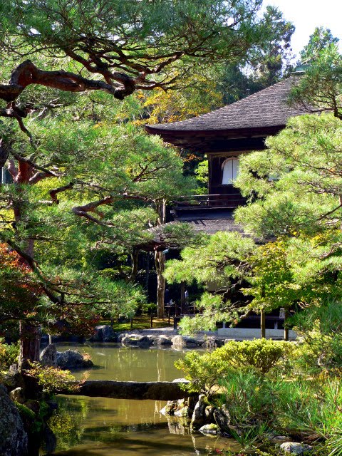
31st October, 2006 - We've come to one of my personal highlights of our trip to Kyōto... Ginkakuji... The Silver Pavilion. Now, I'm sure when you look at the photo above of the aforementioned pavilion you may be thinking "what the...!" This? A highlight? Well, I have to admit the pavilion itself is not that much to look upon... but you have to use a bit of imagination, and also be prepared for a walk... so come join me on this 2 part journey.

The Silver Pavillion is a reference to the earlier completed Golden Pavillion (Kinkakuji). The temple, whose proper name is Jishoji, was constructed by the eighth Ashikaga shogun, Yoshimasa - who had come to be shogun at the ripe old age of eight. Construction originally started in 1460, but with work began in earnest only after his retirement in 1480. As was their wont, the shogun tired of the worldly concerns and turned his back on troubles that beset the country, and began looking for retreat in moon-gazing, tea ceremonies, and dreams of the return of a simpler Heian period.


The first floor is known as the Heart of Emptiness Hall (Shinkuden), and the second floor was known as the Hall of Roaring Waves (Choonden)


The other notable garden is the dry garden which consists of the Sea of Silver Sand (Ginshadan) and the Moon Viewing Platform (Kogetsudai).
The Sea of Silver Sand, Ginshadan


Ginshadan was said to reflect a noted lake in China, and some believe that the Kogestudai refers to the image of Fuji-zan as seen from Sagami Bay. It is however more likely that this strange cone shaped structure was designed to reflect the moons light - and potentially to appear like the moon caught on the water's surface when seen from above. These, as with many of the dry gardens, were designed to be viewed at night, under the light of the moon. Either way, it remains an enigmatic vista before the verdant hills that threaten to envelope it.

The Moon-Viewing Platform...Kogetsudai

The temple was completed in 1482. Whilst the temples is now known as the Silver Pavillion – and it never coated in silver film – unlike it's Golden counterpart. Yoshimasa decreed that, on his death, his private oasis would be converted into a proper Zen temple. The temple now belongs to the Shōkokuji temple, of the Rinzai Zen sect.
The Bridge Welcoming Immortals... Geisenbashi
Yoshimasa is generally considered the designer of the gardens that surround the pavilion. This included the extensive use of very expensive rocks surrounding the Brocade Mirror Pond (Kinkyochi).

The Hall of the Eastern Quest, the Togu-do, is said to be where Yoshimasa lived, and includes a tea-room at the back known as the Dojinsai tea room.
The Hall of the Eastern Quest, Togu-do
The temple grounds has two distinct zones... the lower zone where the temple and lakes can be found; and the upper zone where nature and garden blur beautifully - but we'll see that next post. There are many beautiful areas in the lower zone, and many minutes can be spent wandering around down here alone.

The Sengetsusen... Moon Cleansing Fountain


The Muromachi Period would become famous for the aesthetic pursuits of the aristocracy – also known as the Higashiyama culture – despite the violence and turmoil that surrounded it. Of the original buildings, only the Silver Pavillion itself, and the Togu-do have survived the various fires.

Ironically, whilst Yoshimasa longed for a peaceful retirement, a dispute between his original choice of successor and the child that came later would be the origin of the Onin war (1467-77) in which Kyōto was almost entirely destroyed. Even though the war in the city was over by 1477 AD, most of Japan still struggled with civil unrest. This unrest eventually erupted into outright civil war, and became known as the Warring States Period (sengoku jidai) which ended with Oda Nobunaga in the late 15th century.


By the end of the Onin war, the imperial family was effectively destitute and the Ashikaga shogunate powerless. It therefore represents both the height of the Muromachi aesthetic and the tombstone of 600 years of cultural development as the country slipped rapidly into warring oblivion.
Silver Phoenix atop the Silver Pavilion
The temple was renovated recently - and I understand that is now completed. Having said that - the lower zone of the temple grounds is not what attracts me to this of all temples... that will be discovered in the next post when we visit the upper reaches of the temple grounds.

Posted by Picasa